

Red Granite Grinder 144 race report - Stan Prutz

Stan has traveled all over the world biking from the mountains of Oman to the Tibetan plateau of China.
Stan Prutz returns to Wisconsin for the first time in over 30 years to take on the 144 mile IRONBULL Red Granite Grinder. Stan’s passion for cycling was evident as a toddler as he rode his tricycle around the basement of his dairy farm home in Mosinee. Over the years, he has worked his way through the categories road cycling, then expanded to track, cyclocross, mountain biking and bike packing. Cycling has become part of a healthy lifestyle for Stan, where he loves the community and embraces the challenge.
Stan’s resume is humbling with three consecutive 7-day stage road races through the French Pyrenees, French/Swiss Alps and Italian/Austrian Dolomites in the past five years, approaching 200,000’ of climbing! He’s also bike packed / adventure raced on gravel 700+ miles from Wyoming to Iowa a few times. Now he adds the Red Granite Grinder 144 mile adventure to the list!
“ I would recommend you put this race on your bucket list. The course traverses some of the most beautiful fall countryside I have raced though anywhere in the world.”
Pomp and circumstance start
A chilly low 40’s morning started our day in a downtown Wausau city 400 Block. It was in darkness we prepared for the 7:00AM start. Bikes were buzzing around everywhere as we all made our final preparations. Even in the pre-dawn hours, the local photo club was on duty documenting it all. I and many other racers had conveniently chosen to stay at the Jefferson Street Inn, just a block from the course start.

I’m focused on my footing through the mile hike-a-bike atop Rib Mountain. Photo credit: Coates Photography
I placed drop bags for the 51 and 101 mile aid stations. I put 28psi in my 38mm tubeless tires. I chose a Salsa Cutthroat drop bar mountain bike for this event. At the last minute I added an extra top layer believing 43 degrees needed 4 thin layers rather than the 3 I had planned. That I got right; this worked for me throughout the race.
Race times were tracked with a chip timer embedded in your race number so everyone needed to pass through the timing arch at the start and end of the race. At each aid station plus a few other points volunteers tracked your race numbers to verify everyone stayed on course.
Rise and Grind
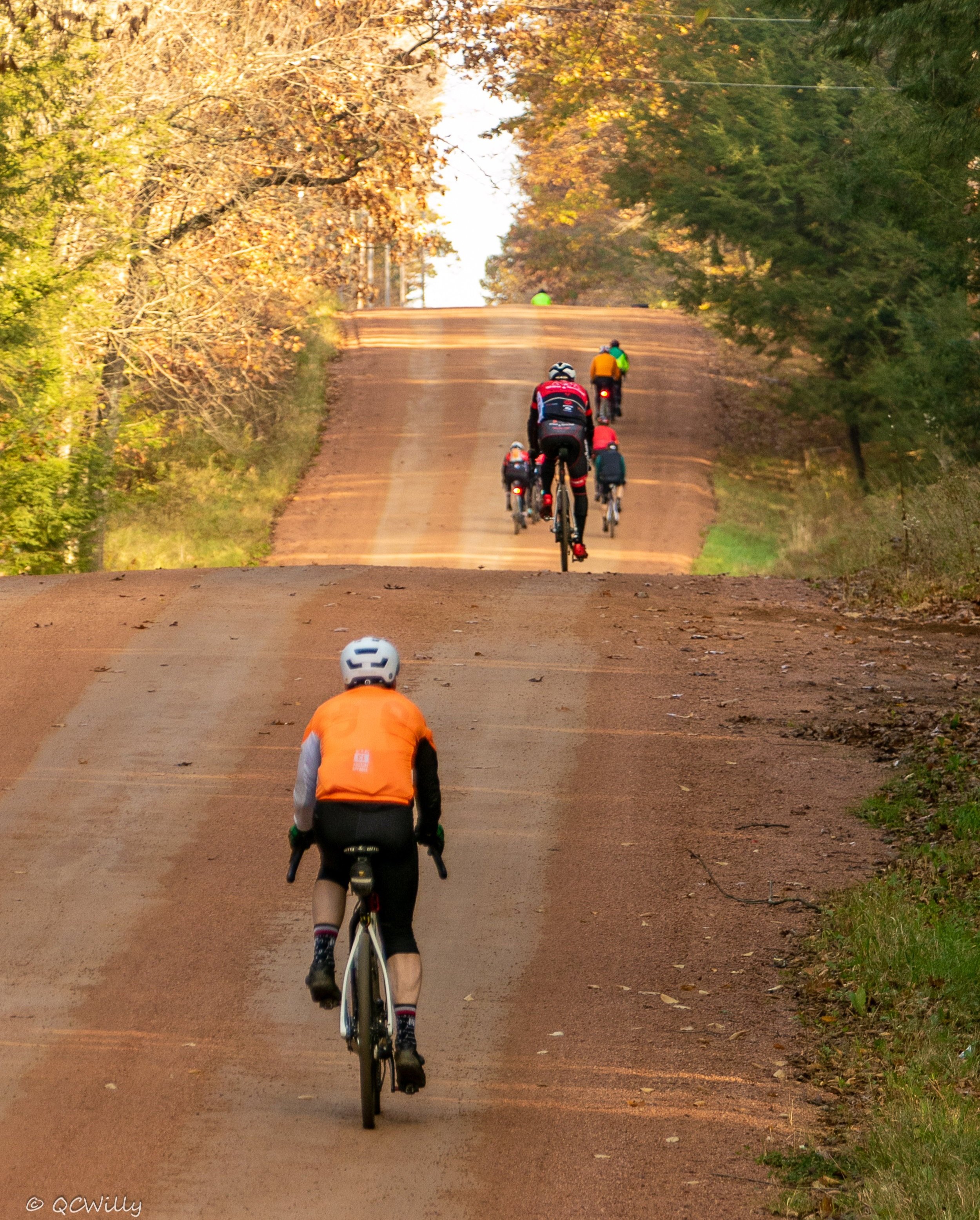
It was a chill group start of several hundred riders as we were together with the 50 and 85 milers. The local police escorted the group and provided road blockages through to the Rib Mountain ascent. This was the first of 5 categorized climbs that showed on my Garmin. Four of the five climbs happened in the first 40 miles and the last was 7 miles from the finish.

Sections such as the Wausau School Forest make tire choice a personal preference based on comfort level. Photo credit: QC Willy
Climbing Rib Mountain is your first test. Do I kill it on the climb to stay with the leaders or pace myself for the 144? I chose the latter. It is about a 700’ paved climb that is 6-8% leveling to 2-4% to the top.
Once you climb Rib Mountain you will take a mandatory hike-a-bike through a narrow single file rocky section half way down the mountain before you can ride again. This was the section of the race that concerned me the most. I broke my left leg severely some years ago and when they put a rod in it they didn’t get the angle quite right, so I have to take some care to not overstretch it. I pushed and sometimes carried my bike through this section. I was grateful I had no trouble keeping up with the others in this section. The race organizers placed a sign to indicate when it is OK to ride again; if you have 38mm tires or larger you can ride down the rest rapidly, MTB shock absorbers not required. Be careful of the railroad ties used at intervals to prevent erosion; you’ll need to slow for these.
Once at the base of the mountain I was rested for the next segment. Now you can enjoy the fall colors as you wind around pavement for 5-8 miles before the grassy Wausau School Forest, the first aid station for all riders. Watch for the IRONBULL signs! You need both your GPS file and the signs to navigate the entire course and this is one of the best marked courses I have ever seen. You’ll encounter a bridge and a bit of singletrack before heading out to ATV trails and then west onto rolling gravel.
Countryside Gems

The boardwalks at Scotch Creek Woodland Preserve keeps us on our toes! Photo credit: Coates Photography
From Rib Mountain to the far southwest corner of the course we rolled through some of the most beautiful countryside of the day. The 15MPH headwind we encountered most of the way, though, was brutal. This made it a good section to be with some other riders, which I was able to do through most of that section.
Once you’ve gone to the far west, you turn north onto gated ATV trails that are in good condition. It was a welcome relief to be free of the headwinds in this section and we rolled fast all the way to the City of Parks - Edgar. The race runs through Edgar’s Scotch Creek Woodland Preserve just east of town, entered near someone’s yard on Wisconsin Avenue (watch for the flags). The preserve is filled with bridges and singletrack carefully marked by the race promoter. You may not find it all rideable! Not the usual thing you would find yourself riding a gravel bike through.
The Back Half
Shortly after this section is the first aid station with drop bags at mile 51 at Hwy 29. It was about 11AM. This was my first break; I stayed a bit along the fence; enjoyed a Gatorade and bar I had packed and then was off.
From here you have a long gravel slog til about mile 85. The challenge for this race was the WNW 15MPH winds. With the many open fields, much of the first 100 miles of the race was into the full wind.
I was really grateful after about mile 85 to take that left and enter private lands with double track that is grassy and sometimes wet and rutted for the next 6 miles, but at least without the wind. The last 10 miles to the mile 101 Averill Creek aid station is typical gravel roads. Half of that was east, so we got a taste of a tailwind at last! The last half into the wind was soul crushing - I was so ready for the rest stop. I took a wrong turn for a bit (due to a vandalized sign) and the person who had been following me the past 15 miles passed me. I’d mark this as the low point in my race.
A Little Help at Averill Creek
At the mile 101 rest stop I really needed a break. In my mind I had divided the race into three races and I knew that each section was progressively easier. The aid station lent me a chair; for me sitting for awhile and getting another Gatorade and bar in me made all the difference. One of the aid station workers placed a headlight I had in my drop bag on my bike, since It was about 3pm and I was calculating 6:30pm was a likely finish time. I was really grateful for how supportive the aid station volunteers were here. Another rider pulled in shortly after I stopped, so I knew I had to get going. He kept his break short and decided to follow me.

Crossing Averill Creek meant opting for a safe crossing rather than dry socks. Photo credit: Coates Photography

Finally getting a break from the wind on an off-road section. Photo credit: QC Willy
After the mile 101 rest stop you cross a steep dirt berm (you probably want to walk) and then the water crossing at Averill Creek. Since there are large rocks to trip up a ride thru, this is most likely a wet feet adventure. In planning I thought this would be a problem but my feet were never cold and the socks dried readily on their own.
After the creek crossing the course continued a few miles through some rough grassy double track to gravel and pavement for the rest of the way back. Now the speeds became the fastest of the day, despite the 100+ miles in the legs. I never saw the fellow behind me again.
Homeward Bound
The last 43 miles was the fastest of the day with a tailwind for all but about 5 miles of the return. Moving faster and knowing you were getting close to the end was motivating. The gravel ends with a kicker, though. At mile 133 you’ll encounter the Billy Goat Hills, a grade 16% followed by a 12% roller. If you’re cramping by this point or you don’t have mountain gearing, you’ll be a walking it here. Fortunately I had done enough course reconnaissance the day before with my brother, course photographer QCWilly, to know to mentally prepare for these last challenges.
A quick descent down pavement to Brokaw and the Wisconsin River, then back up the last paved categorized climb 7 miles from the end (8% average for 3/4 of a mile). After that it is an easy ride into Wausau.
As you enter Wausau be careful to watch for the signs on the main road south that send you to the right to the Wausau Wisconsin River cycleway. There is another sign to hop back off the cycleway onto an adjacent road about a mile down. While you can easily race most of these final city streets, beware. Just before the finish line park is busy one way Scott Street - watch for cars before you cross! I crossed the finish line at dusk about 6:30pm. Have to say the finish was my race highlight! A photographer was there to snap a pic.

One of three finish line photos photographers from Focal Point Photography Club captured of my euphoric moment. Photo credit: Coates Photography
Final Thoughts

During my recon on Friday, I ran into executive director Andrea Larson marking the trails and race director Shane Hitz pre-riding. Photo credit: QC Willy
Temperatures for our 144 mile adventure race were about perfect for me, ranging from 43 to 58 degrees throughout the day. Low hydration needs; just three bottles with nutrition and electrolytes mixed in were all I needed to stay cramp-free. This is no guarantee of how it will be for your race however! The previous year had significant snow fall to contend with.
The local photo club came out to shoot this race; they were popping up everywhere. Thank you QC Willy and the many others from Focal Point Photography Club.
I have raced extensively all over the world. I don’t think I’ve ever been passed by so few people yet ended up so far back in the results (24th of 37). Looking back at it now, I believe if you want to do well in this race, you need to be at the front of the police escort and one of the first to the top of Rib Mountain’s hike-a-bike section, which will allow you to work together with faster riders particularly into the wind during the first 60 miles of the course after which the course splits for 85 and 144 mile riders. I didn’t find anyone else to ride with after first turning north onto the ATV trail, about the 46 mile point.
I spent much of the day battling winds on my own, a lesson learned. Photo credit: QC Willy
Overall, I would recommend you put this race on your bucket list. The course traverses some of the most beautiful fall countryside I have raced though anywhere in the world. I loved the adventure race aspect; it is not just a gravel race; you have numerous sections a mountain bike would have been more appropriate, as well as sections where a road bike would have been more appropriate. Choose your bike setup carefully. Don’t assume you’ll complete this based upon your average gravel times. The climbing, hike-a-bike, singletrack and various adventure sections add extra time. And, of course, the weather can vary greatly any given year. Come prepared to enjoy the adventure of it all!
Related: