

The Far Side of the River - Discovering Grandfather Falls
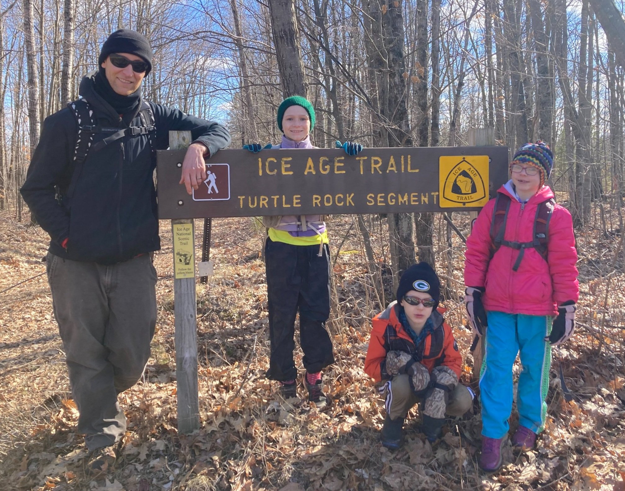
Ready for adventure tackling the Turtle Rock Segment of the Ice Age Trail!
I grew up less than an hour from Grandfather Falls, and I have to admit, I didn’t know it even EXISTED until a couple of years ago. Ever since, it’s been on my radar to check out. Unfortunately, it seemed just too far away to be a convenient quick outing, but at the same time not far enough away to justify a full-blown weekend of activities. The stars finally aligned after my husband suggested a family hike after he spent the prior evening and all morning filing taxes. Although he suggested a local staple, hiking “The Quarry” at Rib Mountain State Park, he was open to finally check out Grandfather Falls on the Ice Age Trail. This was perfectly in line with my recent bug of exploring long distance trails such as the Superior Hiking Trail, North Country Trail, and Ice Age Trail. (Little did he know that I had been listening to a podcast playlist on these topics!) With the in-between spring weather, all of the local mountain bike/fat bike and cross country ski trails are closed, making hiking one of the outdoor activities during the spring thaw / mud season.

As inviting as the bench was to sit and enjoy the Wisconsin River, I told the kids we couldn’t cover up the words until after the photo op!
East or west side?
Although I knew on this blustery March day the Grandfather Falls Segment of the Ice Age Trail on the east side of the river would be far from busy, I thought the open woods, frozen bogs, and lack of bugs was an invitation to explore the Turtle Rock Segment on the west side of the Wisconsin River. Based on this research, I figured we could scout for the possibility to return to thoroughly explore the Merrill School Forest (totaling 10 miles of trails) which includes hiking the Grandfather Falls segment of the Ice Age Trail (4 miles each way) all from our Camp New Wood County Park campsite on a follow-up outing.

The bushwhack through the Lincoln County Forest proved to be a fun shortcut!
Decisions, decisions
As my husband knows, I love looped trails. Like other segments of the Ice Age Trail, the Turtle Rock Segment is also point-to-point; however, after examining various map layers in CalTopo, I determined we had several loop options. We could 1) hike the entire 5 mile segment together then I could run back on the road to the car to pick up the family, 2) cut off the final mile of the segment by bushwhacking north through the Lincoln County Forest to make a loop when we pass directly south of the trailhead (this was my vote and what we chose since it was the shortest overall distance and most adventurous!), or 3) walk back on an old logging trail on the USGS map. Since I didn’t know the conditions of the trails and if the old trail would even be passable, we decided to reserve our decision for when we were literally standing at the fork in the trail. Although I generally love to complete hikes, based on the topo maps it didn’t appear that the final mile would be as exciting as bushwhacking. Luckily when we met our fork in the trail, the rest of the family agreed! I wasn’t surprised after seeing the kids excitedly dig through their drawers for bushwhacking clothes like an excited dog uncovering a bone in the yard before we headed out. What are bushwhacking clothes? Pants that wouldn’t collect burrs, jackets that we wouldn’t mind tearing as we go through the brush and climb rocks, wool socks in case the bogs aren’t fully frozen and our feet get wet, and dry-wicking layers for the blustery afternoon.
After spending time inside at the computer, I went outside for some fresh air and felt more compelled to go inside with the overcast skies and cold temperatures (compared to days before with beautiful sunshine and warm temperatures!) I second guessed our intended afternoon outing. As the sun peeked out on our drive to the trailhead, I thought it may be a good day for a hike after all. The moment I opened the car door, I was thankful I had packed warm gloves and layers, since the blustery winds would have otherwise made our hike unpleasant had we not prepared. On the flip side, had the temperatures been warmer, the trek through the bog wouldn’t have been a viable option.

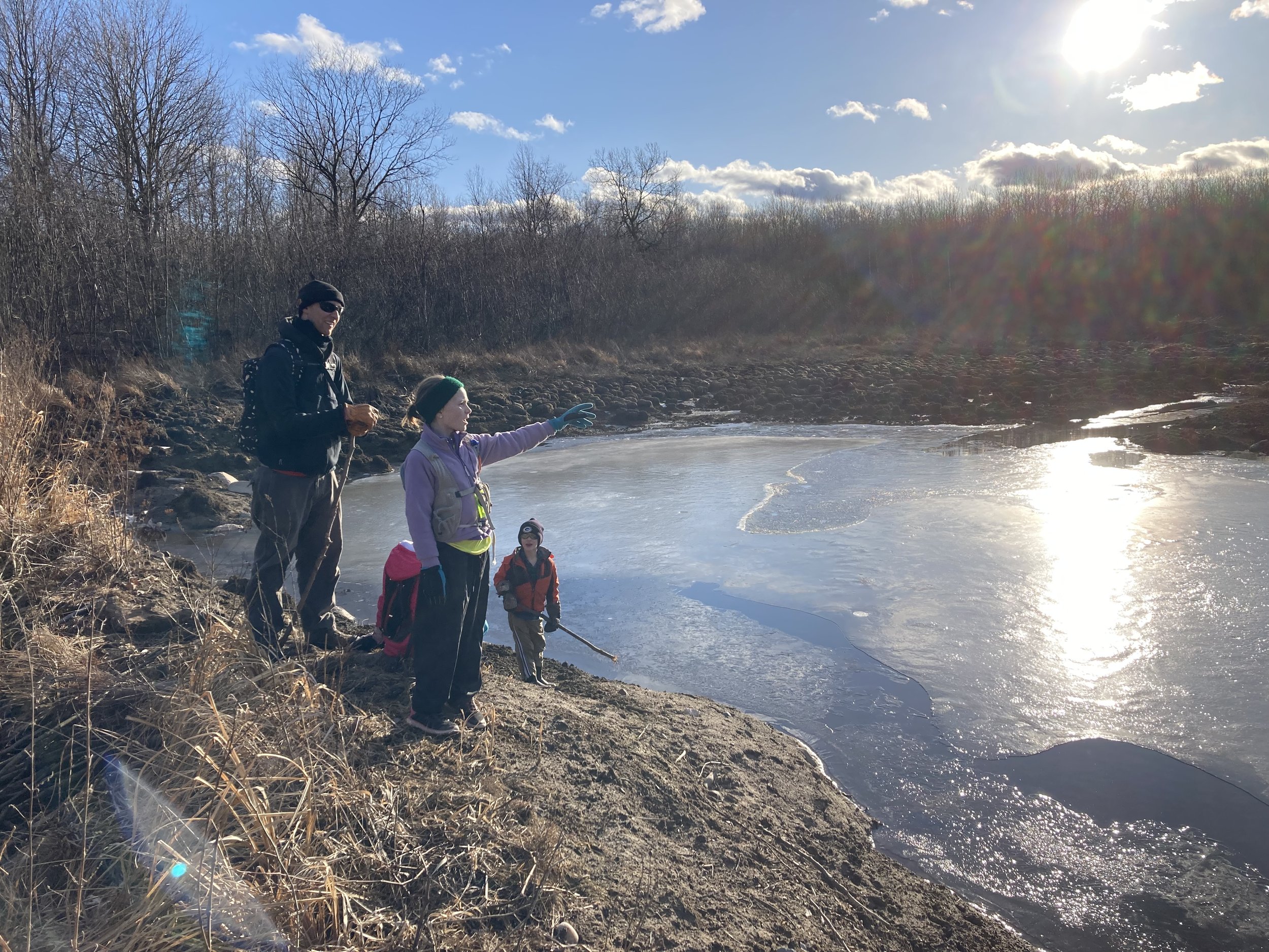
The unnamed creek north of Grandfather Falls added another facet to the hike.
Multi-functional
I had printed out a USGS map so I’d not only be prepared with our route options (especially with lack of cell phone service), but could work on my navigation skills as we hiked. My husband also made the hike multi-functional by carrying a ruck sack with 25 pounds of weights loaded. I took my Fastpackher pack and gladly loaded luxuries such as spare shoes for my youngest, way more water than we needed, and heated gloves and handwarmers with the goal of getting in some (lightweight) rucking in preparations for future trail adventures such as adventure races, a possible FKT attempt on Wisconsin’s North Country Trail, and Marji Gesick 200 run. I hoped to load up oodles of snacks but as soon as my daughters saw me loading up my pack, they all begged to carry packs of their own. With adventure racing season just around the corner, I agreed that it would be a good idea for them to wear their own packs since they will need to in races.
Between my mapreading, my husband’s rucking, and my daughters’ offtrail discoveries, our 5 year old had no trouble maintaining pace. In fact, it wasn’t until we popped out of the woods from our 1/2 mile bushwhack through the bog that he dropped back. He staggered onto the trail having the proudest, most tired expression I’ve seen on his face. Yet he did not utter a single complaint on the hike, even as we stepped over logs, wove between brush, and tiptoed through semi-thawed marsh - all at the same time! Surprisingly, he didn’t conk out on the drive home, but he had no complaints about an early bedtime!
Managing Expectations
On the drive to the trailhead, I explained to the kids that I had never been here and had no idea what to expect. I was glad the second we stepped on the trail that I had primed them. Despite examining several layers of maps, none of them include snowmobile trails specifically. Where we parked across the road on “Log Road” was certainly not a road, but a snowmobile trail. We were all disappointed as we began strolling down the snowmobile trail rather than adventuring on singletrack (luckily it didn’t last long!)
Many discoveries!

My daughters seemed to be attracted like magnets to ice and rocks along the trail.
Soon, we were paralleling an unnamed creek which would empty into the Wisconsin River and hiking on singletrack. The kids seemed to be magnetised with all sorts of things pulling them off the trail. Although we frequently bushwhack, I felt bad telling them they needed to stay on the trail through the private properties, since we didn’t want to compromise the relationship with the generous private property owners who allow the trail through their property! My oldest was drawn to any ice, constantly using sticks to break through the thin ice. I had never seen my middle child this excited about hiking; she climbed up every rock she could find, often towering over us. What a proud mom I was as she completely immersed herself in the adventure! And she can’t wait to do her first adventure race!

Yellow blazes (and rocks) were plentiful on the trail!
After about a mile, we met up with the Wisconsin River. We stopped to take in the view (multiple times). There was no risk of losing the trail; often I could spot three or four blazes on trees! Despite it being early spring, the trail had few sticks on the trail, which made me wonder of the Northwoods Chapter of the Ice Age Alliance had recently maintained the trail.

The kids loved scrambling up the massive rocks that lined (and covered) the trail. However, as they poked their heads into crevices I cautioned them of disrupting a resting animal. As I warned, “Do you think you’d like someone poking you in your bed,” I realized there was potential they could disturb a hibernating black bear!
Grandfather Falls Dam
I threw out a few fun facts that I had recently learned through the Great Pinery Heritage Waterway. Did you know that the Wisconsin River has more dams than any river in the world (26 hydroelectric dams), making it the hardest working river in the world? Be warned: Although Grandfather Falls drops 89 feet over the course of a mile, making it the biggest falls on the entire 420 mile Wisconsin River, I knew not to expect a towering waterfall, but rather a series of rapids. (For more history of Grandfather Falls check out a local historian’s take here.)

I couldn’t help referencing “National Lampoon’s Vacation” and saying we’d take all the dam pictures we want!
When we reached the Wisconsin Public Service (WPS) dam, I gave the kids a quick lesson on conversion of energy (water/hydro to mechanical to electricity) that occur at a hydroelectric dam. With virtually no snowmelt, the river levels were low and the dam wasn’t impressive, despite it generating more electricity on this river than any of the other 25 dams (totaling 101,692 megawatts which is enough to power almost 34,000 homes!). I found myself looking for ways to rock hop across the river where we’d occasionally see a car driving and a few people fishing, but the frigid waters were adequate to keep me off the rocks.

A pileup of reeds along the river was mesmerizing.
Heading back
After a mile along the river, the kids had no problem making the climb away from the river where we turned back onto the snowmobile trail. We strolled back onto singletrack onto subtle landscape. At our attack point for our bushwhack, we found an old logging road. Since it was in the general north direction we decided it would be drier and easier walking with only occasional downed trees compared to the constant downed trees in the woods. Once we felt we were weaving too far west, we stepped off trail for our final leg, roughly a 500 meter bushwhack. In my opinion, this extra obstacle kept the kids more engaged than had we continued meandering on Ice Age Trail. Nonetheless, I have hiking the next segment, Averill-Kelly Creek Wilderness Segment, on my radar!
Marveling at the power of the beaver!
We all marveled at the power of the beaver as we hit the original Ice Age Trail that was currently rerouted due to flooding. Now, as we rejoined the snowmobile trail, we had a new appreciation for the flat, wide, and cleared trail back to the car that we had grumbled about earlier!
We had a mix of favorite parts of the hike - observing an eagle swooping for fish in the river, spotting fresh beaver stumps littering the trail, enjoying the vibrant green moss and ferns, and of course scrambling up rocks! For me, this hike encapsulates what sorts of discoveries can be just down the road! I’m so glad we ventured outside the comfort of our home, layered up, and chose to take a completely new adventure, not knowing what we’d experience! Despite frequently camping at Council Grounds State Park, located just down the road, growing up, I was amazed at the gem I had missed, but thankful my kids discovered!
Related links